ZIP Code 5: 65713 - NIANGUA, MO
ZIP Code 65713 is the postal code in NIANGUA, MO. Besides the basic information, it also lists the full ZIP code and the address of ZIP code 65713. Whatsmore, there is more information related to ZIP Code 65713. For example, nearby ZIP code around ZIP Code 65713, etc.
ZIP 65713 Basic Information

The basic information of ZIP Code 65713 is as follows, including: country, county, city, FIPS and etc.
| State | County | City | ZIP Code 5 |
|---|---|---|---|
| MO - Missouri | Webster County | NIANGUA | 65713 |
| MO - Missouri | Wright County | NIANGUA | 65713 |
📌It means zip code 65713 is across counties/cities.
What is the plus 4 zip code for 65713 ZIP Code? Below is the detail.
65713 ZIP+4 Code List

What are the 4 digit zip extensions of ZIP Code 65713? ZIP code 65713 has many plus 4 codes, and each plus 4 code corresponds to one or more addresses. Below we list all the ZIP+4 codes and their addresses in the ZIP Code 65713. You can find a 9-digit ZIP Code by a full address.
| ZIP Code 5 Plus 4 | Address |
|---|---|
| 65713-0001 | PO BOX 1 (From 1 To 82), NIANGUA, MO |
| 65713-0091 | PO BOX 91 (From 91 To 142), NIANGUA, MO |
| 65713-4200 | 200 (From 200 To 299) SPRUCE ST, NIANGUA, MO |
| 65713-4201 | 100 (From 100 To 199) HAYFIELD DR, NIANGUA, MO |
| 65713-4500 | 1 (From 1 To 99) TURKEY HOLW, NIANGUA, MO |
| 65713-7200 | 200 (From 200 To 299) HONEY LOCUST RD, NIANGUA, MO |
| 65713-7201 | 200 (From 200 To 299) WEBSTER COUNTY LINE RD, NIANGUA, MO |
| 65713-7202 | 1 (From 1 To 99) VICTORY LN, NIANGUA, MO |
| 65713-7203 | 1200 (From 1200 To 1299) QUARRY LN, NIANGUA, MO |
| 65713-7204 | 1200 (From 1200 To 1299) EVANS RD, NIANGUA, MO |
- Page 1
- ››
Post Office in ZIP Code 65713

NIANGUA is the only post office in ZIP Code 65713. You can find the address, phone number, and interactive map below. Click to view the service and service hours about NIANGUA.
-
NIANGUA Post Office

Address 113 S MAIN ST, NIANGUA, MO, 65713-9998
Phone 417-473-6313
*Street Parking Available
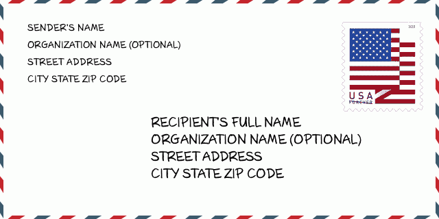
How to write a U.S. envelope?

-
First, you need to fill in the recipient's mailing information in the center of the envelope. The first line is the recipient's name, the second line is the street address with a detailed house number, and the last line is the city, state abbr, and ZIP Code.
Second, write the sender's information on the left top corner of the envelope. If your mail cannot be delivered, it will return to the sender's address.
Finally, don't forget to stick the stamp on the right top corner. Otherwise, the letter will not go into the delivery process.
Here is the envelope example below.
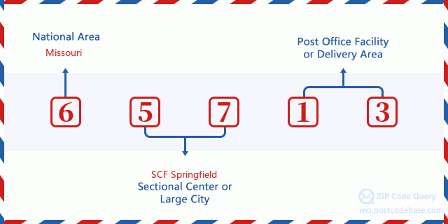
What does each digit of ZIP Code 65713 stand for?
-
The first digit designates a national area, which ranges from zero for the Northeast to nine for the far West.
The 2-3 digits represent a sectional center facility in that region.
The last two digits designate small post offices or postal zones.
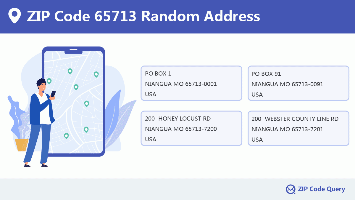
Random Address in ZIP 65713

ZIP Code 65713 has 1,220 real random addresses, you can clicking the picture below to get random addresses in ZIP Code 65713.
ZIP 65713 Online Map

This is online map of the address NIANGUA, Laclede County, Missouri. You may use button to move and zoom in / out. The map information is for reference only.
ZIP 65713 NearBy ZIP Code
The Nearby ZIP Codes are 65632, 65706, 65662, 65722, and 65667, you can find ZIP codes in a 25km radius around ZIP Code 65713 and the approximate distance between the two ZIP codes.
The data has a slight deviation for your reference only.

School in ZIP Code 65713

This is the ZIP Code 65713 - School page list. Its detail School Name, Address, City, State, ZIP Code is as below.
| School Name | Address | City | State | Grades | ZIP Code |
|---|---|---|---|---|---|
| Niangua Elem. | 301 Rumsey St | Niangua | Missouri | KG-6 | 65713 |
| Niangua High | 301 Rumsey St | Niangua | Missouri | 7-12 | 65713 |
Comment


Add new comment