ZIP Code 5: 63091 - ROSEBUD, MO
ZIP Code 63091 is the postal code in ROSEBUD, MO. Besides the basic information, it also lists the full ZIP code and the address of ZIP code 63091. Whatsmore, there is more information related to ZIP Code 63091. For example, nearby ZIP code around ZIP Code 63091, etc.
ZIP 63091 Basic Information

The basic information of ZIP Code 63091 is as follows, including: country, county, city, FIPS and etc.
| State | County | City | ZIP Code 5 |
|---|---|---|---|
| MO - Missouri | Franklin County | ROSEBUD | 63091 |
| MO - Missouri | Gasconade County | ROSEBUD | 63091 |
📌It means zip code 63091 is across counties/cities.
What is the plus 4 zip code for 63091 ZIP Code? Below is the detail.
63091 ZIP+4 Code List

What are the 4 digit zip extensions of ZIP Code 63091? ZIP code 63091 has many plus 4 codes, and each plus 4 code corresponds to one or more addresses. Below we list all the ZIP+4 codes and their addresses in the ZIP Code 63091. You can find a 9-digit ZIP Code by a full address.
| ZIP Code 5 Plus 4 | Address |
|---|---|
| 63091-1018 | 220 HIGHWAY 50, ROSEBUD, MO |
| 63091-1019 | 206 HIGHWAY 50, ROSEBUD, MO |
| 63091-1020 | 224 (From 224 To 226 Even) HIGHWAY 50, ROSEBUD, MO |
| 63091-1021 | 232 (From 232 To 234 Even) HIGHWAY 50, ROSEBUD, MO |
| 63091-1022 | 501 (From 501 To 599 Odd) PINE ST, ROSEBUD, MO |
| 63091-1023 | 500 (From 500 To 598 Even) PINE ST, ROSEBUD, MO |
| 63091-1024 | 243 (From 243 To 245 Odd) HIGHWAY 50, ROSEBUD, MO |
| 63091-1025 | 101 (From 101 To 199 Odd) RESERVE ST, ROSEBUD, MO |
| 63091-1026 | 208 (From 208 To 214 Even) HIGHWAY 50, ROSEBUD, MO |
| 63091-1027 | 216 HIGHWAY 50, ROSEBUD, MO |
Post Office in ZIP Code 63091

ROSEBUD is the only post office in ZIP Code 63091. You can find the address, phone number, and interactive map below. Click to view the service and service hours about ROSEBUD.
-
ROSEBUD Post Office

Address 257 HIGHWAY 50, ROSEBUD, MO, 63091-9998
Phone 573-764-2643
*Lot Parking Available
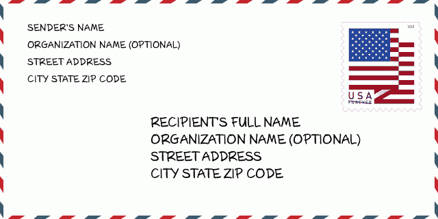
How to write a U.S. envelope?

-
First, you need to fill in the recipient's mailing information in the center of the envelope. The first line is the recipient's name, the second line is the street address with a detailed house number, and the last line is the city, state abbr, and ZIP Code.
Second, write the sender's information on the left top corner of the envelope. If your mail cannot be delivered, it will return to the sender's address.
Finally, don't forget to stick the stamp on the right top corner. Otherwise, the letter will not go into the delivery process.
Here is the envelope example below.
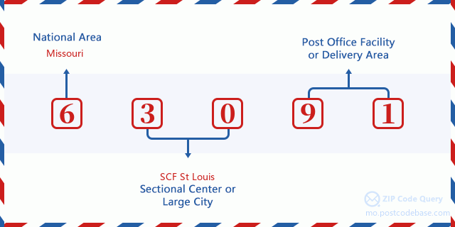
What does each digit of ZIP Code 63091 stand for?
-
The first digit designates a national area, which ranges from zero for the Northeast to nine for the far West.
The 2-3 digits represent a sectional center facility in that region.
The last two digits designate small post offices or postal zones.
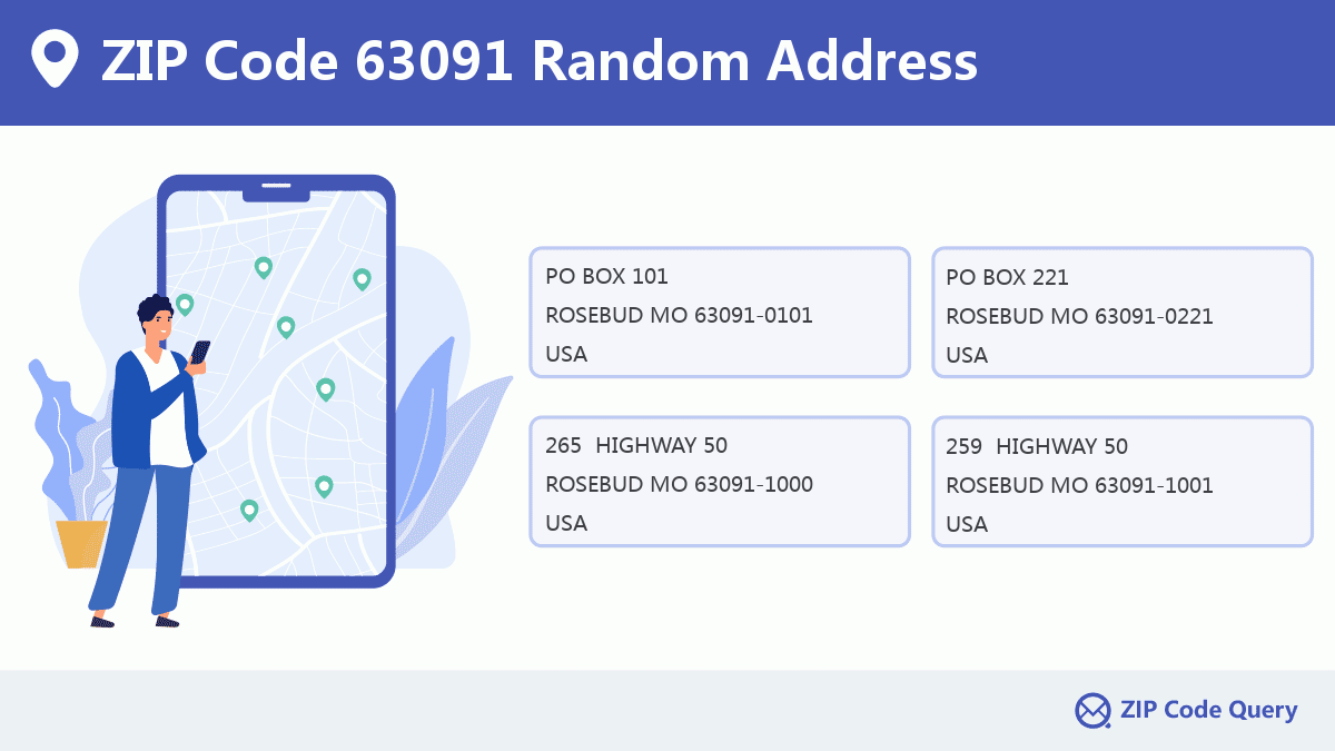
Random Address in ZIP 63091

ZIP Code 63091 has 636 real random addresses, you can clicking the picture below to get random addresses in ZIP Code 63091.
ZIP 63091 Online Map

This is online map of the address ROSEBUD, Franklin County, Missouri. You may use button to move and zoom in / out. The map information is for reference only.
ZIP 63091 NearBy ZIP Code
The Nearby ZIP Codes are 65066, 63037, 63056, 63013, and 63080, you can find ZIP codes in a 25km radius around ZIP Code 63091 and the approximate distance between the two ZIP codes.
The data has a slight deviation for your reference only.

Comment


Add new comment