ZIP Code 5: 64461 - HOPKINS, MO
ZIP Code 64461 is the postal code in HOPKINS, MO. Besides the basic information, it also lists the full ZIP code and the address of ZIP code 64461. Whatsmore, there is more information related to ZIP Code 64461. For example, nearby ZIP code around ZIP Code 64461, etc.
ZIP 64461 Basic Information

The basic information of ZIP Code 64461 is as follows, including: country, county, city, FIPS and etc.
| State | County | City | ZIP Code 5 |
|---|---|---|---|
| MO - Missouri | Nodaway County | HOPKINS | 64461 |
What is the plus 4 zip code for 64461 ZIP Code? Below is the detail.
64461 ZIP+4 Code List

What are the 4 digit zip extensions of ZIP Code 64461? ZIP code 64461 has many plus 4 codes, and each plus 4 code corresponds to one or more addresses. Below we list all the ZIP+4 codes and their addresses in the ZIP Code 64461. You can find a 9-digit ZIP Code by a full address.
| ZIP Code 5 Plus 4 | Address |
|---|---|
| 64461-7202 | 14800 (From 14800 To 14899) KATY RD, HOPKINS, MO |
| 64461-7203 | 14900 (From 14900 To 14999) KATY RD, HOPKINS, MO |
| 64461-7204 | 14500 (From 14500 To 14599) STATE HIGHWAY AC, HOPKINS, MO |
| 64461-7205 | 100 (From 100 To 199) 5TH ST, HOPKINS, MO |
| 64461-7206 | 13700 (From 13700 To 13799) STATE HIGHWAY AC, HOPKINS, MO |
| 64461-7207 | 12100 (From 12100 To 12199) STATE HIGHWAY AC, HOPKINS, MO |
| 64461-7208 | 13900 (From 13900 To 13999) LANTERN RD, HOPKINS, MO |
| 64461-7209 | 30700 (From 30700 To 30799) 135TH ST, HOPKINS, MO |
| 64461-7210 | 13300 (From 13300 To 13399) LEOPARD RD, HOPKINS, MO |
| 64461-7211 | 32600 (From 32600 To 32699) 130TH ST, HOPKINS, MO |
Post Office in ZIP Code 64461

HOPKINS is the only post office in ZIP Code 64461. You can find the address, phone number, and interactive map below. Click to view the service and service hours about HOPKINS.
-
HOPKINS Post Office

Address 401 E BARNARD ST, HOPKINS, MO, 64461-9998
Phone 660-778-3211
*Street Parking Available
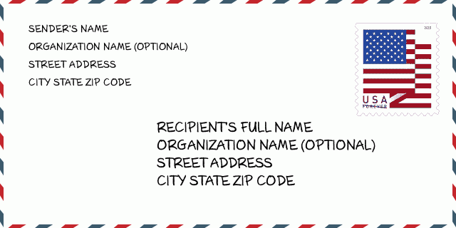
How to write a U.S. envelope?

-
First, you need to fill in the recipient's mailing information in the center of the envelope. The first line is the recipient's name, the second line is the street address with a detailed house number, and the last line is the city, state abbr, and ZIP Code.
Second, write the sender's information on the left top corner of the envelope. If your mail cannot be delivered, it will return to the sender's address.
Finally, don't forget to stick the stamp on the right top corner. Otherwise, the letter will not go into the delivery process.
Here is the envelope example below.
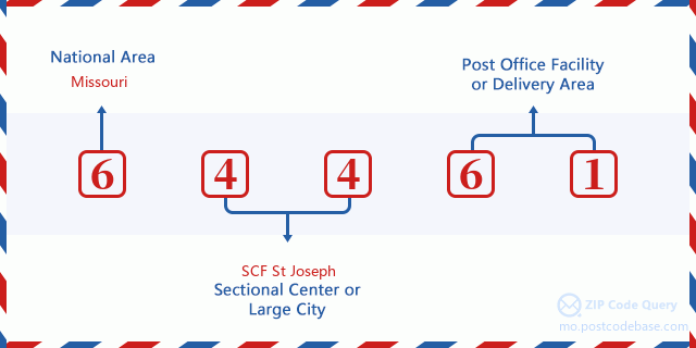
What does each digit of ZIP Code 64461 stand for?
-
The first digit designates a national area, which ranges from zero for the Northeast to nine for the far West.
The 2-3 digits represent a sectional center facility in that region.
The last two digits designate small post offices or postal zones.
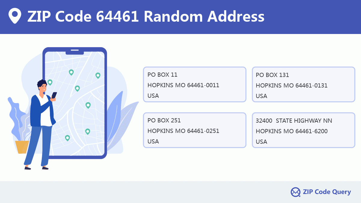
Random Address in ZIP 64461

ZIP Code 64461 has 412 real random addresses, you can clicking the picture below to get random addresses in ZIP Code 64461.
ZIP 64461 Online Map

This is online map of the address HOPKINS, Nodaway County, Missouri. You may use button to move and zoom in / out. The map information is for reference only.
ZIP 64461 NearBy ZIP Code
The Nearby ZIP Codes are 64476, 64475, 64431, 51631, and 50833, you can find ZIP codes in a 25km radius around ZIP Code 64461 and the approximate distance between the two ZIP codes.
The data has a slight deviation for your reference only.

Museum in ZIP Code 64461

-
HOPKINS HISTORICAL SOCIETY
Phone:Discipline: Historical Societies, Historic PreservationAddress: 113 NORTH THIRD STREET, HOPKINS MO 64461, USA
School in ZIP Code 64461

This is the ZIP Code 64461 - School page list. Its detail School Name, Address, City, State, ZIP Code is as below.
- ·School Name:North Nodaway Jr.-sr. High
- ·Address: Po Box 260
- ·City: Hopkins
- ·State: Missouri
- ·Grades: 6-12
- ·ZIP Code: 64461
Comment


Add new comment